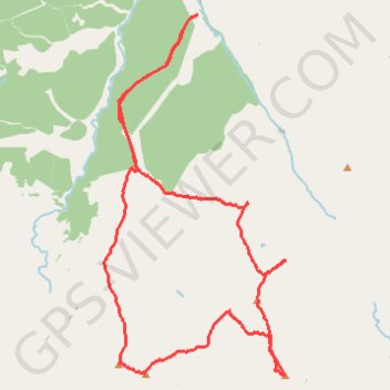
Munro hillwalk Grey Corries
Munro, hillwalk, Grey, Corries
- Distance: 15.7 mi
- Elevation gain: 1,851 m
- Maximum elevation: 1,169 m
- Elevation loss: 1,851 m
- Minimum elevation: 137 m
- Moving time: 8 h 15 m
- Moving speed: 1.9 mph
- Maximum speed: 20.4 mph
- Total time: 9 h 37 m
- Global speed: 1.6 mph
Interactive trail map
Trail profile
- Distance: 15.7 mi
- Elevation gain: 1,851 m
- Maximum elevation: 1,169 m
- Elevation loss: 1,851 m
- Minimum elevation: 137 m
- Moving time: 8 h 15 m
- Moving speed: 1.9 mph
- Maximum speed: 20.4 mph
- Total time: 9 h 37 m
- Global speed: 1.6 mph
About this trail
Name: Munro hillwalk Grey Corries trail, distance, elevation, map, profile, GPS track
Start: Bridge 16, Highland, Scotland, PH31 4AQ, United Kingdom (56.87277 -4.86824)
End: Bridge 16, Highland, Scotland, PH31 4AQ, United Kingdom (56.87276 -4.86817)
Coordinates: 56.81053 -4.89782 56.87277 -4.84055
Topography: Highland topographic map, elevation, terrain
Other hiking, mountain biking, running and outdoor activity trails
Click on a trail to view its statistics, map and profile.
Great Glen Way (Fort William to Fort Augustus)
United Kingdom > Scotland > Highland > Fort William
Distance: 32.7 mi • Elevation gain: 598 m • Maximum elevation: 108 m