Thank you for supporting this site ❤️
Make a donation
Make a donation
Gear up for your next adventure:
As an Amazon Associate, this site earns from qualifying purchases at no extra cost to you.
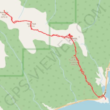
Traverse of Windy Point Ridge via The Buckle, Talus Peak and Navicular Peak
Scrambling, mountain, peak
- Distance: 7.8 mi
- Elevation gain: 1,496 m
- Maximum elevation: 2,289 m
- Elevation loss: 1,497 m
- Minimum elevation: 1,330 m
- Moving time: 6 h 14 m
- Moving speed: 1.3 mph
- Maximum speed: 3.3 mph
- Total time: 15 h 7 m
- Global speed: 0.5 mph
Interactive trail map
Thank you for supporting this site ❤️
Make a donation
Make a donation
Gear up for your next adventure:
As an Amazon Associate, this site earns from qualifying purchases at no extra cost to you.
Trail profile
- Distance: 7.8 mi
- Elevation gain: 1,496 m
- Maximum elevation: 2,289 m
- Elevation loss: 1,497 m
- Minimum elevation: 1,330 m
- Moving time: 6 h 14 m
- Moving speed: 1.3 mph
- Maximum speed: 3.3 mph
- Total time: 15 h 7 m
- Global speed: 0.5 mph
Thank you for supporting this site ❤️
Make a donation
Make a donation
Gear up for your next adventure:
As an Amazon Associate, this site earns from qualifying purchases at no extra cost to you.
About this trail
Name: Traverse of Windy Point Ridge via The Buckle, Talus Peak and Navicular Peak trail, distance, elevation, map, profile, GPS track
Start: Highway 11, Clearwater County, Alberta, Canada (52.25414 -116.39208)
End: Clearwater County, Alberta, Canada (52.25425 -116.39188)
Coordinates: 52.25414 -116.43784 52.27876 -116.39187
Thank you for supporting this site ❤️
Make a donation
Make a donation
Gear up for your next adventure:
As an Amazon Associate, this site earns from qualifying purchases at no extra cost to you.