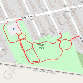
Tranby Park
- Distance: 1.2 mi
- Elevation gain: 4 m
- Maximum elevation: 181 m
- Elevation loss: 4 m
- Minimum elevation: 179 m
- Moving time: 10 m 27 s
- Moving speed: 6.7 mph
- Maximum speed: 9.4 mph
- Total time: 10 m 27 s
- Global speed: 6.7 mph
Interactive trail map
Trail profile
- Distance: 1.2 mi
- Elevation gain: 4 m
- Maximum elevation: 181 m
- Elevation loss: 4 m
- Minimum elevation: 179 m
- Moving time: 10 m 27 s
- Moving speed: 6.7 mph
- Maximum speed: 9.4 mph
- Total time: 10 m 27 s
- Global speed: 6.7 mph
About this trail
Name: Tranby Park trail, distance, elevation, map, profile, GPS track
Start: Tranby Avenue, Windsor, Ontario, N8S 4R6, Canada (42.32080 -82.94880)
End: Tranby Avenue, Windsor, Ontario, N8S 4R6, Canada (42.32088 -82.94796)
Coordinates: 42.31891 -82.94910 42.32088 -82.94448