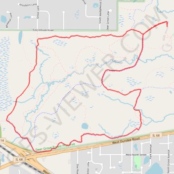
Deer Grove Forest Preserve loop
Cook County Walking
- Distance: 4.3 mi
- Elevation gain: 46 m
- Maximum elevation: 271 m
- Elevation loss: 47 m
- Minimum elevation: 248 m
- Moving time: 1 h 19 m
- Moving speed: 3.2 mph
- Maximum speed: 4.0 mph
- Total time: 1 h 20 m
- Global speed: 3.2 mph
Interactive trail map
Trail profile
- Distance: 4.3 mi
- Elevation gain: 46 m
- Maximum elevation: 271 m
- Elevation loss: 47 m
- Minimum elevation: 248 m
- Moving time: 1 h 19 m
- Moving speed: 3.2 mph
- Maximum speed: 4.0 mph
- Total time: 1 h 20 m
- Global speed: 3.2 mph
About this trail
Name: Deer Grove Forest Preserve loop trail, distance, elevation, map, profile, GPS track
Coordinates: 42.13422 -88.09639 42.14758 -88.07417