Thank you for supporting this site ❤️
Make a donation
Make a donation
Gear up for your next adventure:
As an Amazon Associate, this site earns from qualifying purchases at no extra cost to you.
Shustoke Circular walk
- Distance: 6.0 mi
- Elevation gain: 62 m
- Maximum elevation: 102 m
- Elevation loss: 63 m
- Minimum elevation: 68 m
- Moving time: 2 h 25 m
- Moving speed: 2.5 mph
- Maximum speed: 5.3 mph
- Total time: 3 h 26 m
- Global speed: 1.7 mph
Interactive trail map
Thank you for supporting this site ❤️
Make a donation
Make a donation
Gear up for your next adventure:
As an Amazon Associate, this site earns from qualifying purchases at no extra cost to you.
Trail profile
- Distance: 6.0 mi
- Elevation gain: 62 m
- Maximum elevation: 102 m
- Elevation loss: 63 m
- Minimum elevation: 68 m
- Moving time: 2 h 25 m
- Moving speed: 2.5 mph
- Maximum speed: 5.3 mph
- Total time: 3 h 26 m
- Global speed: 1.7 mph
Thank you for supporting this site ❤️
Make a donation
Make a donation
Gear up for your next adventure:
As an Amazon Associate, this site earns from qualifying purchases at no extra cost to you.
About this trail
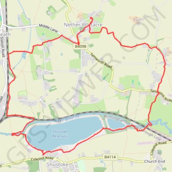
Name: Shustoke Circular walk trail, distance, elevation, map, profile, GPS track
Coordinates: 52.51597 -1.67746 52.53471 -1.64199
Topography: North Warwickshire topographic map, elevation, terrain
Thank you for supporting this site ❤️
Make a donation
Make a donation
Gear up for your next adventure:
As an Amazon Associate, this site earns from qualifying purchases at no extra cost to you.