Thank you for supporting this site ❤️
Make a donation
Make a donation
Gear up for your next adventure:
As an Amazon Associate, this site earns from qualifying purchases at no extra cost to you.
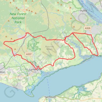
Downhill to Brock – Beaulieu Heath Road Loop from Sway
- Distance: 38.9 mi
- Elevation gain: 378 m
- Maximum elevation: 62 m
- Elevation loss: 378 m
- Minimum elevation: -1 m
- Moving time: 2 h 47 m
- Moving speed: 14.0 mph
- Maximum speed: 33.9 mph
- Total time: 2 h 47 m
- Global speed: 14.0 mph
Interactive trail map
Thank you for supporting this site ❤️
Make a donation
Make a donation
Gear up for your next adventure:
As an Amazon Associate, this site earns from qualifying purchases at no extra cost to you.
Trail profile
- Distance: 38.9 mi
- Elevation gain: 378 m
- Maximum elevation: 62 m
- Elevation loss: 378 m
- Minimum elevation: -1 m
- Moving time: 2 h 47 m
- Moving speed: 14.0 mph
- Maximum speed: 33.9 mph
- Total time: 2 h 47 m
- Global speed: 14.0 mph
Thank you for supporting this site ❤️
Make a donation
Make a donation
Gear up for your next adventure:
As an Amazon Associate, this site earns from qualifying purchases at no extra cost to you.
About this trail
Name: Downhill to Brock – Beaulieu Heath Road Loop from Sway trail, distance, elevation, map, profile, GPS track
Coordinates: 50.75829 -1.63837 50.82800 -1.35473
Topography: New Forest topographic map, elevation, terrain
Thank you for supporting this site ❤️
Make a donation
Make a donation
Gear up for your next adventure:
As an Amazon Associate, this site earns from qualifying purchases at no extra cost to you.