Import a GPX file

Dr. John Champlin Glacier Park Loop Trails

  • Distance: 3.2 mi
  • Elevation gain: 43 m
  • Maximum elevation: 31 m
  • Elevation loss: 43 m
  • Minimum elevation: 10 m
  • Moving time: 35 m 25 s
  • Moving speed: 5.4 mph
  • Maximum speed: 10.2 mph
  • Total time: 36 m 12 s
  • Global speed: 5.3 mph

Interactive trail map

Trail profile

  • Distance: 3.2 mi
  • Elevation gain: 43 m
  • Maximum elevation: 31 m
  • Elevation loss: 43 m
  • Minimum elevation: 10 m
  • Moving time: 35 m 25 s
  • Moving speed: 5.4 mph
  • Maximum speed: 10.2 mph
  • Total time: 36 m 12 s
  • Global speed: 5.3 mph

About this trail

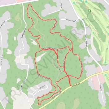
Name: Dr. John Champlin Glacier Park Loop Trails trail, distance, elevation, map, profile, GPS track

Start: Shore Road, Haversham, Misquamicut, Westerly, South County, Rhode Island, 02891, United States (41.33546 -71.80006)

End: Shore Road, Haversham, Misquamicut, Westerly, South County, Rhode Island, 02891, United States (41.33548 -71.80001)

Coordinates: 41.33360 -71.80566 41.34328 -71.79861

Gear up for your next adventure:

🧭Orienteering Compasses - Accurate compasses for map-based navigation
🪢Paracord - Multi-purpose cord for camping and survival
📚UK Hiking Guidebooks - Detailed route descriptions for the Lake District, Peaks, and Highlands
📦Compression Sacks - Reduce backpack volume efficiently
🔥Reusable Hand Warmers - Maintain dexterity in your fingers for precise map handling

As an Amazon Associate, this site earns from qualifying purchases at no extra cost to you.