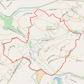
Loop walk in Hitchcock woods
- Distance: 4.6 mi
- Elevation gain: 117 m
- Maximum elevation: 130 m
- Elevation loss: 116 m
- Minimum elevation: 89 m
- Moving time: 1 h 35 m
- Moving speed: 2.9 mph
- Maximum speed: 13.3 mph
- Total time: 1 h 39 m
- Global speed: 2.8 mph
Interactive trail map
Trail profile
- Distance: 4.6 mi
- Elevation gain: 117 m
- Maximum elevation: 130 m
- Elevation loss: 116 m
- Minimum elevation: 89 m
- Moving time: 1 h 35 m
- Moving speed: 2.9 mph
- Maximum speed: 13.3 mph
- Total time: 1 h 39 m
- Global speed: 2.8 mph
About this trail
Name: Loop walk in Hitchcock woods trail, distance, elevation, map, profile, GPS track
Start: Tea Cottage Path, Westcliff, Aiken County, South Carolina, 29801, United States (33.55619 -81.75311)
End: Tea Cottage Path, Westcliff, Aiken County, South Carolina, 29801, United States (33.55604 -81.75289)
Coordinates: 33.54061 -81.76291 33.55619 -81.74116