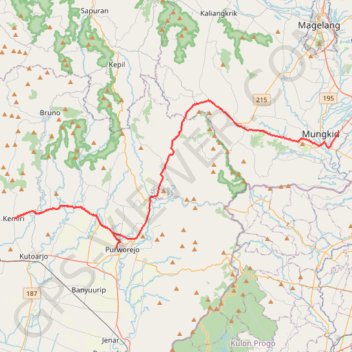
Track 1
- Distance: 52.0 mi
- Elevation gain: 679 m
- Maximum elevation: 471 m
- Elevation loss: 875 m
- Minimum elevation: 17 m
Interactive trail map
Trail profile
- Distance: 52.0 mi
- Elevation gain: 679 m
- Maximum elevation: 471 m
- Elevation loss: 875 m
- Minimum elevation: 17 m
About this trail
Name: Track 1 trail, distance, elevation, map, profile, GPS track
Coordinates: -7.71596 109.89307 -7.55693 110.23949
Other hiking, mountain biking, running and outdoor activity trails
Click on a trail to view its statistics, map and profile.
Benjaw day 3
Indonesia > Central Java > Kebumen > Bumirejo
Distance: 221.7 mi • Elevation gain: 4,241 m • Maximum elevation: 588 m
BENTANGJAWA2024_FINAL
Indonesia > West Java > Sukabumi > Tegalbuleud > Panaruban
Distance: 712.8 mi • Elevation gain: 12,308 m • Maximum elevation: 2,460 m
Benjaw day 3
Indonesia > Central Java > Kebumen > Bumirejo
Distance: 221.7 mi • Elevation gain: 4,241 m • Maximum elevation: 588 m