Teepee Trail
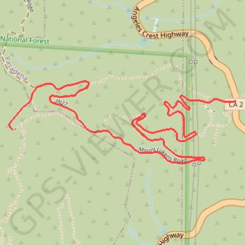
Interactive trail map
Trail profile
- Distance: 2.6 mi
- Elevation gain: 380 m
- Maximum elevation: 985 m
- Elevation loss: 95 m
- Minimum elevation: 694 m
About this trail
Name: Teepee Trail trail, distance, elevation, map, profile, GPS track
Coordinates: 34.23082 -118.19772 34.23506 -118.18364
Other hiking, mountain biking, running and outdoor activity trails
Click on a trail to view its statistics, map and profile.
Gabrielino Trail
United States > California > Los Angeles County
Starting from Chantry Flat, the Gabrielino Trail slips from the shaded ridge above Big Santa Anita Canyon into a classic Angeles National Forest corridor of wooded slopes, creekside cabins and canyon-bottom shade. The route passes the lower canyon junctions, Cascade Picnic Area and Spruce Grove Trail Camp…
Distance: 27.6 mi • Elevation gain: 2,358 m • Maximum elevation: 1,421 m