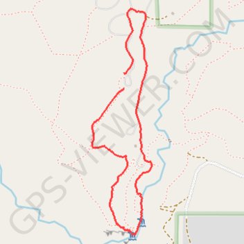
Jemez Falls Campsite
- Distance: 2.0 mi
- Elevation gain: 65 m
- Maximum elevation: 2,444 m
- Elevation loss: 64 m
- Minimum elevation: 2,380 m
- Moving time: 52 m 20 s
- Moving speed: 2.2 mph
- Maximum speed: 4.1 mph
- Total time: 1 h 43 m
- Global speed: 1.1 mph
Interactive trail map
Trail profile
- Distance: 2.0 mi
- Elevation gain: 65 m
- Maximum elevation: 2,444 m
- Elevation loss: 64 m
- Minimum elevation: 2,380 m
- Moving time: 52 m 20 s
- Moving speed: 2.2 mph
- Maximum speed: 4.1 mph
- Total time: 1 h 43 m
- Global speed: 1.1 mph
About this trail
Name: Jemez Falls Campsite trail, distance, elevation, map, profile, GPS track
Start: Loop 4, Sandoval County, New Mexico, 87025, United States (35.82002 -106.60741)
End: 46, Loop 4, Sandoval County, New Mexico, 87025, United States (35.82085 -106.60742)
Coordinates: 35.81252 -106.60945 35.82414 -106.60566