Import a GPX file

Warrie Circuit - Springbrook National Park

#Hiking #Loop

  • Distance: 9.3 mi
  • Elevation gain: 1,002 m
  • Maximum elevation: 760 m
  • Elevation loss: 1,002 m
  • Minimum elevation: 358 m

Interactive trail map

Trail profile

  • Distance: 9.3 mi
  • Elevation gain: 1,002 m
  • Maximum elevation: 760 m
  • Elevation loss: 1,002 m
  • Minimum elevation: 358 m

About this trail
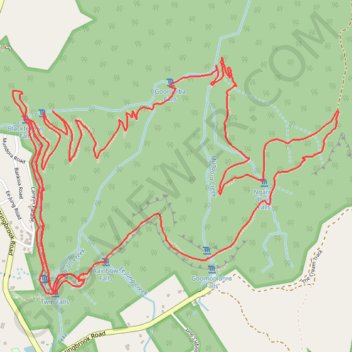
Name: Warrie Circuit - Springbrook National Park trail, distance, elevation, map, profile, GPS track

Start: Canyon Lookout, Twin Falls Circuit, Springbrook, Gold Coast City, Queensland, Australia (-28.22067 153.27304)

End: Twin Falls Circuit, Springbrook, Gold Coast City, Queensland, Australia (-28.22064 153.27304)

Coordinates: -28.22469 153.27130 -28.21044 153.29358

Other hiking, mountain biking, running and outdoor activity trails

Click on a trail to view its statistics, map and profile.
Warrie Loop Trail

Australia > Queensland > Gold Coast City

Springbrook National Park. #Hiking #Loop #Springbrook

Distance: 8.2 mi • Elevation gain: 942 m • Maximum elevation: 776 m

Gear up for your next adventure:

💧Hydration Reservoirs - Convenient water bladders for hands-free drinking on the move
🧴Sport Sunscreen Sticks - High-protection sunblock that won't run into your eyes on the trail
🥾Women's Waterproof Hiking Boots - High-performance trekking boots designed for all-weather comfort
🖼️Topographic Map Art - Decorative 3D-effect posters of famous UK peaks and regions
☕Insulated Travel Mugs - Keep drinks hot while surveying the landscape from a summit

As an Amazon Associate, this site earns from qualifying purchases at no extra cost to you.