Thank you for supporting this site ❤️
Make a donation
Make a donation
Gear up for your next adventure:
As an Amazon Associate, this site earns from qualifying purchases at no extra cost to you.
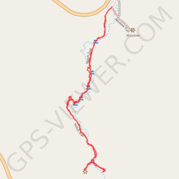
Notch trail
Hike along the Notch Creek on the Notch trail in the Badlands National Park. #Hiking #Nature #Park
- Distance: 1.4 mi
- Elevation gain: 52 m
- Maximum elevation: 853 m
- Elevation loss: 52 m
- Minimum elevation: 806 m
- Moving time: 49 m 1 s
- Moving speed: 1.8 mph
- Maximum speed: 4.0 mph
- Total time: 1 h 11 m
- Global speed: 1.2 mph
Interactive trail map
Thank you for supporting this site ❤️
Make a donation
Make a donation
Gear up for your next adventure:
As an Amazon Associate, this site earns from qualifying purchases at no extra cost to you.
Trail profile
- Distance: 1.4 mi
- Elevation gain: 52 m
- Maximum elevation: 853 m
- Elevation loss: 52 m
- Minimum elevation: 806 m
- Moving time: 49 m 1 s
- Moving speed: 1.8 mph
- Maximum speed: 4.0 mph
- Total time: 1 h 11 m
- Global speed: 1.2 mph
Thank you for supporting this site ❤️
Make a donation
Make a donation
Gear up for your next adventure:
As an Amazon Associate, this site earns from qualifying purchases at no extra cost to you.
About this trail
Name: Notch trail trail, distance, elevation, map, profile, GPS track
Start: Notch Trail, Jackson County, South Dakota, 57750, United States (43.76007 -101.92824)
Coordinates: 43.75297 -101.93072 43.76029 -101.92796
Thank you for supporting this site ❤️
Make a donation
Make a donation
Gear up for your next adventure:
As an Amazon Associate, this site earns from qualifying purchases at no extra cost to you.