Make a donation
Gear up for your next adventure:
As an Amazon Associate, this site earns from qualifying purchases at no extra cost to you.
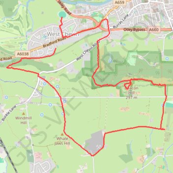
Otley Chevin
- Distance: 5.4 mi
- Elevation gain: 238 m
- Maximum elevation: 278 m
- Elevation loss: 251 m
- Minimum elevation: 60 m
- Moving time: 2 h 44 m
- Moving speed: 2.0 mph
- Maximum speed: 10.3 mph
- Total time: 4 h 20 m
- Global speed: 1.3 mph
Interactive trail map
Make a donation
Gear up for your next adventure:
As an Amazon Associate, this site earns from qualifying purchases at no extra cost to you.
Trail profile
- Distance: 5.4 mi
- Elevation gain: 238 m
- Maximum elevation: 278 m
- Elevation loss: 251 m
- Minimum elevation: 60 m
- Moving time: 2 h 44 m
- Moving speed: 2.0 mph
- Maximum speed: 10.3 mph
- Total time: 4 h 20 m
- Global speed: 1.3 mph
Make a donation
Gear up for your next adventure:
As an Amazon Associate, this site earns from qualifying purchases at no extra cost to you.
About this trail
Name: Otley Chevin trail, distance, elevation, map, profile, GPS track
Coordinates: 53.88445 -1.72464 53.90206 -1.69017
Topography: England topographic map, elevation, terrain
Make a donation
Gear up for your next adventure:
As an Amazon Associate, this site earns from qualifying purchases at no extra cost to you.
Other hiking, mountain biking, running and outdoor activity trails
Click on a trail to view its statistics, map and profile.
Otley - Eccup Reservoir - Harewood Bank - Otley (bicycle)
United Kingdom > England > Otley
Distance: 21.7 mi • Elevation gain: 377 m • Maximum elevation: 179 m
Otley - Eccup Reservoir - Harewood Bank - Otley (bicycle)
United Kingdom > England > Otley
Distance: 21.5 mi • Elevation gain: 364 m • Maximum elevation: 178 m
Otley - Draughton/Skipton Moor and return
United Kingdom > England > Leeds
Distance: 25.7 mi • Elevation gain: 456 m • Maximum elevation: 318 m
Make a donation
Gear up for your next adventure:
As an Amazon Associate, this site earns from qualifying purchases at no extra cost to you.