Thank you for supporting this site ❤️
Make a donation
Make a donation
Gear up for your next adventure:
As an Amazon Associate, this site earns from qualifying purchases at no extra cost to you.
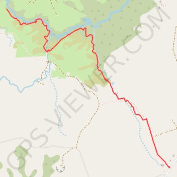
Mangakaretu Upper Track
- Distance: 2.2 mi
- Elevation gain: 60 m
- Maximum elevation: 308 m
- Elevation loss: 50 m
- Minimum elevation: 269 m
- Moving time: 49 m 41 s
- Moving speed: 2.7 mph
- Maximum speed: 3.9 mph
- Total time: 1 h 4 m
- Global speed: 2.1 mph
Interactive trail map
Thank you for supporting this site ❤️
Make a donation
Make a donation
Gear up for your next adventure:
As an Amazon Associate, this site earns from qualifying purchases at no extra cost to you.
Trail profile
- Distance: 2.2 mi
- Elevation gain: 60 m
- Maximum elevation: 308 m
- Elevation loss: 50 m
- Minimum elevation: 269 m
- Moving time: 49 m 41 s
- Moving speed: 2.7 mph
- Maximum speed: 3.9 mph
- Total time: 1 h 4 m
- Global speed: 2.1 mph
Thank you for supporting this site ❤️
Make a donation
Make a donation
Gear up for your next adventure:
As an Amazon Associate, this site earns from qualifying purchases at no extra cost to you.
About this trail
Name: Mangakaretu Upper Track trail, distance, elevation, map, profile, GPS track
Coordinates: -35.23557 173.80586 -35.22072 173.82459
Thank you for supporting this site ❤️
Make a donation
Make a donation
Gear up for your next adventure:
As an Amazon Associate, this site earns from qualifying purchases at no extra cost to you.