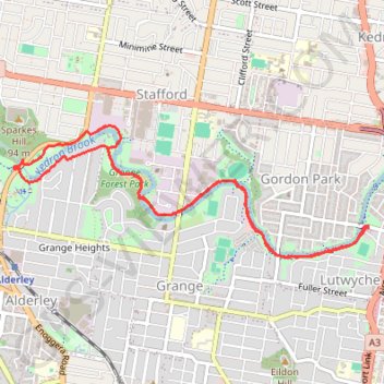
Kedron Brook Track
Interactive trail map
Trail profile
- Distance: 5.7 mi
- Elevation gain: 88 m
- Maximum elevation: 38 m
- Elevation loss: 88 m
- Minimum elevation: 13 m
- Moving time: 1 h 29 m
- Moving speed: 3.8 mph
- Maximum speed: 9.7 mph
- Total time: 1 h 29 m
- Global speed: 3.8 mph
About this trail
Name: Kedron Brook Track trail, distance, elevation, map, profile, GPS track
Start: Bradshaw Street, Lutwyche, Greater Brisbane, Queensland, 4030, Australia (-27.42012 153.03223)
End: 71, Thistle Street, Lutwyche, Greater Brisbane, Queensland, 4030, Australia (-27.42016 153.03212)
Coordinates: -27.42248 153.00083 -27.41214 153.03223
Other hiking, mountain biking, running and outdoor activity trails
Click on a trail to view its statistics, map and profile.