Creekside Trails
Mountain Biking
- Distance: 12.9 mi
- Elevation gain: 133 m
- Maximum elevation: 249 m
- Elevation loss: 133 m
- Minimum elevation: 204 m
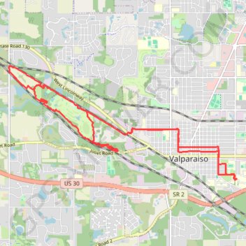
Interactive trail map
Trail profile
- Distance: 12.9 mi
- Elevation gain: 133 m
- Maximum elevation: 249 m
- Elevation loss: 133 m
- Minimum elevation: 204 m
About this trail
Name: Creekside Trails trail, distance, elevation, map, profile, GPS track
Coordinates: 41.46245 -87.11417 41.48792 -87.04606
Other hiking, mountain biking, running and outdoor activity trails
Click on a trail to view its statistics, map and profile.
Creekside Trails
United States > Indiana > Porter County > Valparaiso
Distance: 17.5 mi • Elevation gain: 229 m • Maximum elevation: 220 m