Mount Crawford
Hike from Saco River to Mount Crawford via Davis Path and Mount Crawford Spur in the Presidential Range-Dry River Wilderness. #Hiking #Mountain #River #Nature #Forest #Wilderness
- Distance: 4.6 mi
- Elevation gain: 629 m
- Maximum elevation: 931 m
- Elevation loss: 627 m
- Minimum elevation: 301 m
- Moving time: 2 h 12 m
- Moving speed: 2.1 mph
- Maximum speed: 3.6 mph
- Total time: 2 h 37 m
- Global speed: 1.7 mph
Interactive trail map
Trail profile
- Distance: 4.6 mi
- Elevation gain: 629 m
- Maximum elevation: 931 m
- Elevation loss: 627 m
- Minimum elevation: 301 m
- Moving time: 2 h 12 m
- Moving speed: 2.1 mph
- Maximum speed: 3.6 mph
- Total time: 2 h 37 m
- Global speed: 1.7 mph
About this trail
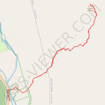
Name: Mount Crawford trail, distance, elevation, map, profile, GPS track
Coordinates: 44.11840 -71.35407 44.13682 -71.33079
Other hiking, mountain biking, running and outdoor activity trails
Click on a trail to view its statistics, map and profile.