Thank you for supporting this site ❤️
Make a donation
Make a donation
Gear up for your next adventure:
As an Amazon Associate, this site earns from qualifying purchases at no extra cost to you.
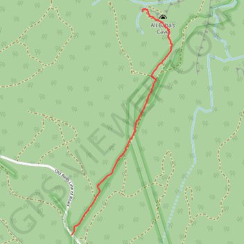
Bung Crag Pagoda Environs
- Distance: 1.3 mi
- Elevation gain: 8 m
- Maximum elevation: 1,112 m
- Elevation loss: 126 m
- Minimum elevation: 989 m
Interactive trail map
Thank you for supporting this site ❤️
Make a donation
Make a donation
Gear up for your next adventure:
As an Amazon Associate, this site earns from qualifying purchases at no extra cost to you.
Trail profile
- Distance: 1.3 mi
- Elevation gain: 8 m
- Maximum elevation: 1,112 m
- Elevation loss: 126 m
- Minimum elevation: 989 m
Thank you for supporting this site ❤️
Make a donation
Make a donation
Gear up for your next adventure:
As an Amazon Associate, this site earns from qualifying purchases at no extra cost to you.
About this trail
Name: Bung Crag Pagoda Environs trail, distance, elevation, map, profile, GPS track
Coordinates: -33.43511 150.22653 -33.42033 150.23442
Thank you for supporting this site ❤️
Make a donation
Make a donation
Gear up for your next adventure:
As an Amazon Associate, this site earns from qualifying purchases at no extra cost to you.