Thank you for supporting this site ❤️
Make a donation
Make a donation
Gear up for your next adventure:
As an Amazon Associate, this site earns from qualifying purchases at no extra cost to you.
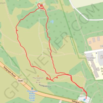
Tracks on Thurstaston Hill to Thor's Rock
- Distance: 0.7 mi
- Elevation gain: 22 m
- Maximum elevation: 85 m
- Elevation loss: 22 m
- Minimum elevation: 70 m
- Moving time: 27 m 42 s
- Moving speed: 1.6 mph
- Maximum speed: 2.6 mph
- Total time: 1 h 9 m
- Global speed: 0.6 mph
Interactive trail map
Thank you for supporting this site ❤️
Make a donation
Make a donation
Gear up for your next adventure:
As an Amazon Associate, this site earns from qualifying purchases at no extra cost to you.
Trail profile
- Distance: 0.7 mi
- Elevation gain: 22 m
- Maximum elevation: 85 m
- Elevation loss: 22 m
- Minimum elevation: 70 m
- Moving time: 27 m 42 s
- Moving speed: 1.6 mph
- Maximum speed: 2.6 mph
- Total time: 1 h 9 m
- Global speed: 0.6 mph
Thank you for supporting this site ❤️
Make a donation
Make a donation
Gear up for your next adventure:
As an Amazon Associate, this site earns from qualifying purchases at no extra cost to you.
About this trail
Name: Tracks on Thurstaston Hill to Thor's Rock trail, distance, elevation, map, profile, GPS track
Coordinates: 53.35273 -3.13762 53.35592 -3.13365
Topography: England topographic map, elevation, terrain
Thank you for supporting this site ❤️
Make a donation
Make a donation
Gear up for your next adventure:
As an Amazon Associate, this site earns from qualifying purchases at no extra cost to you.