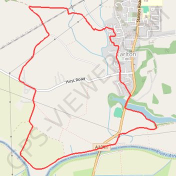
Carlton Loop Walk
- Distance: 4.5 mi
- Elevation gain: 19 m
- Maximum elevation: 9 m
- Elevation loss: 19 m
- Minimum elevation: 3 m
- Moving time: 1 h 4 m
- Moving speed: 4.1 mph
- Maximum speed: 5.1 mph
- Total time: 1 h 4 m
- Global speed: 4.1 mph
Interactive trail map
Trail profile
- Distance: 4.5 mi
- Elevation gain: 19 m
- Maximum elevation: 9 m
- Elevation loss: 19 m
- Minimum elevation: 3 m
- Moving time: 1 h 4 m
- Moving speed: 4.1 mph
- Maximum speed: 5.1 mph
- Total time: 1 h 4 m
- Global speed: 4.1 mph
About this trail
Name: Carlton Loop Walk trail, distance, elevation, map, profile, GPS track
Coordinates: 53.69546 -1.04228 53.71381 -1.01603
Topography: North Yorkshire topographic map, elevation, terrain
Other hiking, mountain biking, running and outdoor activity trails
Click on a trail to view its statistics, map and profile.
Gravel ride loop from Sheffield to Hornsea and York
United Kingdom > England > Sheffield
Distance: 207.1 mi • Elevation gain: 1,836 m • Maximum elevation: 222 m
T1
United Kingdom > England > North Yorkshire > Selby
Distance: 63.9 mi • Elevation gain: 297 m • Maximum elevation: 9 m