Make a donation
Gear up for your next adventure:
As an Amazon Associate, this site earns from qualifying purchases at no extra cost to you.
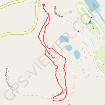
Forest Heritage Tree Trail in Beavers Bend State Park
The Forest Heritage Tree Trail offers a serene hiking experience, winding through a diverse array of native tree species while providing informative signage that enhances the educational aspect of the journey. As you traverse the loop, you'll encounter picturesque views, including a charming covered bridge and the tranquil waters of Beaver Creek, which add to the trail's scenic appeal. This relatively easy hike is perfect for families and nature enthusiasts, showcasing the region's natural beauty in every season, especially during the vibrant autumn foliage. #Hiking #Loop #Forest #Nature
- Distance: 1.2 mi
- Elevation gain: 36 m
- Maximum elevation: 160 m
- Elevation loss: 35 m
- Minimum elevation: 137 m
- Moving time: 32 m 17 s
- Moving speed: 2.2 mph
- Maximum speed: 4.1 mph
- Total time: 35 m 21 s
- Global speed: 2.0 mph
Interactive trail map
Make a donation
Gear up for your next adventure:
As an Amazon Associate, this site earns from qualifying purchases at no extra cost to you.
Trail profile
- Distance: 1.2 mi
- Elevation gain: 36 m
- Maximum elevation: 160 m
- Elevation loss: 35 m
- Minimum elevation: 137 m
- Moving time: 32 m 17 s
- Moving speed: 2.2 mph
- Maximum speed: 4.1 mph
- Total time: 35 m 21 s
- Global speed: 2.0 mph
Make a donation
Gear up for your next adventure:
As an Amazon Associate, this site earns from qualifying purchases at no extra cost to you.
About this trail
Name: Forest Heritage Tree Trail in Beavers Bend State Park trail, distance, elevation, map, profile, GPS track
Start: Heritage Trail, McCurtain County, Oklahoma, United States (34.13253 -94.68034)
End: OK 259A, McCurtain County, Oklahoma, United States (34.13253 -94.68047)
Coordinates: 34.12582 -94.68080 34.13253 -94.67846
Make a donation
Gear up for your next adventure:
As an Amazon Associate, this site earns from qualifying purchases at no extra cost to you.
Other hiking, mountain biking, running and outdoor activity trails
Click on a trail to view its statistics, map and profile.
Lookout Mountain Loop in Beavers Bend State Park
United States > Oklahoma > McCurtain County
The Lookout Mountain Loop offers a scenic and moderately challenging hike through lush forests and elevated terrain. Hikers can enjoy picturesque views of the surrounding landscape, including the meandering Mountain Fork River and diverse rock formations, such as Blaylock sandstone and volcanic tuff.…
Distance: 2.2 mi • Elevation gain: 134 m • Maximum elevation: 247 m
Campgrounds in Beaver Bend
United States > Oklahoma > McCurtain County
Distance: 6.2 mi • Elevation gain: 116 m • Maximum elevation: 148 m