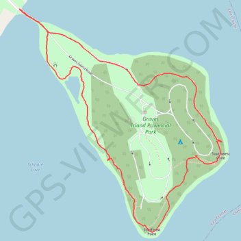
Thank you for supporting this site ❤️
Make a donation
Make a donation
Gear up for your next adventure:
As an Amazon Associate, this site earns from qualifying purchases at no extra cost to you.
Graves Island Loop
Interactive trail map
Thank you for supporting this site ❤️
Make a donation
Make a donation
Gear up for your next adventure:
As an Amazon Associate, this site earns from qualifying purchases at no extra cost to you.
Trail profile
- Distance: 2.2 mi
- Elevation gain: 52 m
- Maximum elevation: 22 m
- Elevation loss: 52 m
- Minimum elevation: 0 m
- Moving time: 48 m 13 s
- Moving speed: 2.7 mph
- Maximum speed: 4.2 mph
- Total time: 1 h 2 m
- Global speed: 2.1 mph
Thank you for supporting this site ❤️
Make a donation
Make a donation
Gear up for your next adventure:
As an Amazon Associate, this site earns from qualifying purchases at no extra cost to you.
About this trail
Name: Graves Island Loop trail, distance, elevation, map, profile, GPS track
Coordinates: 44.55474 -64.21360 44.56412 -64.20162
Thank you for supporting this site ❤️
Make a donation
Make a donation
Gear up for your next adventure:
As an Amazon Associate, this site earns from qualifying purchases at no extra cost to you.