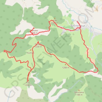
Jablanica - Ljuljaš, Kik, Orlić
- Distance: 8.3 mi
- Elevation gain: 772 m
- Maximum elevation: 1,261 m
- Elevation loss: 771 m
- Minimum elevation: 835 m
- Moving time: 3 h 40 m
- Moving speed: 2.3 mph
- Maximum speed: 9.6 mph
- Total time: 5 h 41 m
- Global speed: 1.5 mph
Interactive trail map
Trail profile
- Distance: 8.3 mi
- Elevation gain: 772 m
- Maximum elevation: 1,261 m
- Elevation loss: 771 m
- Minimum elevation: 835 m
- Moving time: 3 h 40 m
- Moving speed: 2.3 mph
- Maximum speed: 9.6 mph
- Total time: 5 h 41 m
- Global speed: 1.5 mph
About this trail
Name: Jablanica - Ljuljaš, Kik, Orlić trail, distance, elevation, map, profile, GPS track
Coordinates: 43.63571 19.55280 43.65402 19.59159
Other hiking, mountain biking, running and outdoor activity trails
Click on a trail to view its statistics, map and profile.
2022_Yu
Slovenia > Ajdovščina > Žapuže
Distance: 1,526.9 mi • Elevation gain: 32,048 m • Maximum elevation: 1,950 m
Jablanica - Jelova gora - Tornik - Liska - Jablanica
Serbia > Central Serbia > Zlatibor Administrative District > Cajetina Municipality > Jablanica
Distance: 10.2 mi • Elevation gain: 942 m • Maximum elevation: 1,487 m
Јабланица - Радов поток - Томов поток - Јабланица
Serbia > Central Serbia > Zlatibor Administrative District > Cajetina Municipality > Jablanica
Distance: 5.6 mi • Elevation gain: 741 m • Maximum elevation: 1,206 m
Stublo memorijalni uspon Aleksandar Džavić Planine zovu, pla...
Serbia > Central Serbia > Zlatibor Administrative District > Cajetina Municipality > Stublo
Distance: 9.6 mi • Elevation gain: 684 m • Maximum elevation: 1,299 m