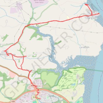
Saltash Cargreen
- Distance: 8.9 mi
- Elevation gain: 278 m
- Maximum elevation: 77 m
- Elevation loss: 298 m
- Minimum elevation: 0 m
- Moving time: 3 h 29 m
- Moving speed: 2.6 mph
- Maximum speed: 6.1 mph
- Total time: 3 h 50 m
- Global speed: 2.3 mph
Interactive trail map
Trail profile
- Distance: 8.9 mi
- Elevation gain: 278 m
- Maximum elevation: 77 m
- Elevation loss: 298 m
- Minimum elevation: 0 m
- Moving time: 3 h 29 m
- Moving speed: 2.6 mph
- Maximum speed: 6.1 mph
- Total time: 3 h 50 m
- Global speed: 2.3 mph
About this trail
Name: Saltash Cargreen trail, distance, elevation, map, profile, GPS track
Start: Saltash, Cornwall, England, PL12 6PG, United Kingdom (50.42282 -4.23798)
Coordinates: 50.41625 -4.24991 50.44550 -4.20367
Topography: Cornwall topographic map, elevation, terrain