Make a donation
Gear up for your next adventure:
As an Amazon Associate, this site earns from qualifying purchases at no extra cost to you.
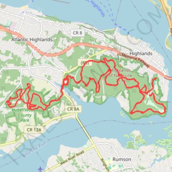
Hartshorne Woods Park & Huber Woods County Park
- Distance: 25.7 mi
- Elevation gain: 825 m
- Maximum elevation: 79 m
- Elevation loss: 825 m
- Minimum elevation: 0 m
- Moving time: 3 h 43 m
- Moving speed: 6.9 mph
- Maximum speed: 19.8 mph
- Total time: 4 h 29 m
- Global speed: 5.7 mph
Interactive trail map
Make a donation
Gear up for your next adventure:
As an Amazon Associate, this site earns from qualifying purchases at no extra cost to you.
Trail profile
- Distance: 25.7 mi
- Elevation gain: 825 m
- Maximum elevation: 79 m
- Elevation loss: 825 m
- Minimum elevation: 0 m
- Moving time: 3 h 43 m
- Moving speed: 6.9 mph
- Maximum speed: 19.8 mph
- Total time: 4 h 29 m
- Global speed: 5.7 mph
Make a donation
Gear up for your next adventure:
As an Amazon Associate, this site earns from qualifying purchases at no extra cost to you.
About this trail
Name: Hartshorne Woods Park & Huber Woods County Park trail, distance, elevation, map, profile, GPS track
Coordinates: 40.38550 -74.04426 40.40227 -73.98182
Make a donation
Gear up for your next adventure:
As an Amazon Associate, this site earns from qualifying purchases at no extra cost to you.
Other hiking, mountain biking, running and outdoor activity trails
Click on a trail to view its statistics, map and profile.
Atlantic highlands
United States > New Jersey > Monmouth County > Middletown Township > Stone Church
A Perfect Summer Day
Distance: 35.5 mi • Elevation gain: 726 m • Maximum elevation: 79 m
Hartshorne Huber Beach
United States > New Jersey > Monmouth County > Middletown Township > Stone Church
Hartshorne Woods Park
Distance: 38.1 mi • Elevation gain: 1,250 m • Maximum elevation: 79 m