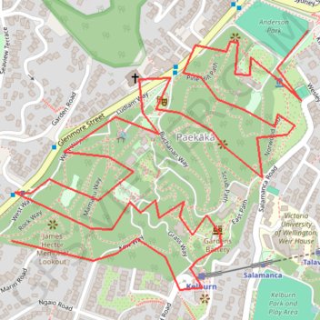
Shiny Party Wellington NZ GPX Route.gpx
- Distance: 2.7 mi
- Elevation gain: 131 m
- Maximum elevation: 123 m
- Elevation loss: 180 m
- Minimum elevation: 56 m
Interactive trail map
Trail profile
- Distance: 2.7 mi
- Elevation gain: 131 m
- Maximum elevation: 123 m
- Elevation loss: 180 m
- Minimum elevation: 56 m
About this trail
Name: Shiny Party Wellington NZ GPX Route.gpx trail, distance, elevation, map, profile, GPS track
Coordinates: -41.28565 174.76202 -41.27978 174.77096
Other hiking, mountain biking, running and outdoor activity trails
Click on a trail to view its statistics, map and profile.
Shiny Party Wellington NZ GPX Route.gpx
New Zealand > Wellington > Wellington City > Wellington
Distance: 2.7 mi • Elevation gain: 124 m • Maximum elevation: 123 m
Welington
New Zealand > Wellington > Wellington City > Wellington
Distance: 46.3 mi • Elevation gain: 886 m • Maximum elevation: 223 m