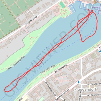
MpowerRpiA1-24-03-2024_14-44#0
- Distance: 1.2 mi
- Elevation gain: 3 m
- Maximum elevation: 58 m
- Elevation loss: 2 m
- Minimum elevation: 55 m
- Moving time: 13 m 49 s
- Moving speed: 5.3 mph
- Maximum speed: 12.6 mph
- Total time: 1 h 46 m
- Global speed: 0.7 mph
Interactive trail map
Trail profile
- Distance: 1.2 mi
- Elevation gain: 3 m
- Maximum elevation: 58 m
- Elevation loss: 2 m
- Minimum elevation: 55 m
- Moving time: 13 m 49 s
- Moving speed: 5.3 mph
- Maximum speed: 12.6 mph
- Total time: 1 h 46 m
- Global speed: 0.7 mph
About this trail
Name: MpowerRpiA1-24-03-2024_14-44#0 trail, distance, elevation, map, profile, GPS track
Coordinates: 51.95274 7.60767 51.95716 7.61577
Other hiking, mountain biking, running and outdoor activity trails
Click on a trail to view its statistics, map and profile.
Eurovelo 15 - Strasbourg Rotterdam
France > Grand Est > Bas-Rhin > Strasbourg
Distance: 554.1 mi • Elevation gain: 2,104 m • Maximum elevation: 146 m
PT23BS1 Kiel → Lörrach
Germany > Schleswig-Holstein > Kiel
Distance: 650.4 mi • Elevation gain: 9,265 m • Maximum elevation: 757 m