Pleasant - Lyttelton
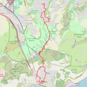
Interactive trail map
Trail profile
- Distance: 7.7 mi
- Elevation gain: 677 m
- Maximum elevation: 408 m
- Elevation loss: 685 m
- Minimum elevation: 8 m
- Moving time: 2 h 26 m
- Moving speed: 3.1 mph
- Maximum speed: 7.6 mph
- Total time: 2 h 43 m
- Global speed: 2.8 mph
About this trail
Name: Pleasant - Lyttelton trail, distance, elevation, map, profile, GPS track
Coordinates: -43.60338 172.71663 -43.56809 172.72503
Other hiking, mountain biking, running and outdoor activity trails
Click on a trail to view its statistics, map and profile.
Lyttelton to Sumner Walk
New Zealand > Canterbury > Christchurch City > Banks Peninsula Community > Lyttelton
Hike from Lyttelton to Sumner via Chalmers Track, Mount Pleasant Bluffs Track, Summit Road and Windsor Castle in the Tauhinu-Korokio Scenic Reserve and the Greenwood Park. #Hiking #Walking #Nature #Mountain #Park #Forest #Sea #Pacific #Ocean
Distance: 4.4 mi • Elevation gain: 411 m • Maximum elevation: 418 m