Make a donation
Gear up for your next adventure:
As an Amazon Associate, this site earns from qualifying purchases at no extra cost to you.
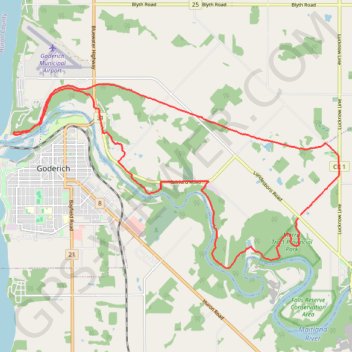
Morris Tract Provincial Nature Reserve - Maitland River
Lake Huron. #Hiking #Loop #MorrisTract #Huron
- Distance: 14.7 mi
- Elevation gain: 325 m
- Maximum elevation: 276 m
- Elevation loss: 326 m
- Minimum elevation: 181 m
Interactive trail map
Make a donation
Gear up for your next adventure:
As an Amazon Associate, this site earns from qualifying purchases at no extra cost to you.
Trail profile
- Distance: 14.7 mi
- Elevation gain: 325 m
- Maximum elevation: 276 m
- Elevation loss: 326 m
- Minimum elevation: 181 m
Make a donation
Gear up for your next adventure:
As an Amazon Associate, this site earns from qualifying purchases at no extra cost to you.
About this trail
Name: Morris Tract Provincial Nature Reserve - Maitland River trail, distance, elevation, map, profile, GPS track
Coordinates: 43.72243 -81.72243 43.76028 -81.62965
Make a donation
Gear up for your next adventure:
As an Amazon Associate, this site earns from qualifying purchases at no extra cost to you.
Other hiking, mountain biking, running and outdoor activity trails
Click on a trail to view its statistics, map and profile.
Morris Tract Provincial Nature Reserve - Maitland River
Canada > Ontario > Huron County > Ashfield–Colborne–Wawanosh
#Hiking #Loop #MorrisTract #Maitland
Distance: 5.8 mi • Elevation gain: 180 m • Maximum elevation: 268 m