Nanango - Brisbane River
Nanango State Forest. Mount Stanley State Forest. #MTB #Nanango #MountStanley
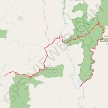
- Distance: 32.4 mi
- Elevation gain: 1,004 m
- Maximum elevation: 546 m
- Elevation loss: 1,237 m
- Minimum elevation: 169 m
Interactive trail map
Trail profile
- Distance: 32.4 mi
- Elevation gain: 1,004 m
- Maximum elevation: 546 m
- Elevation loss: 1,237 m
- Minimum elevation: 169 m
About this trail
Name: Nanango - Brisbane River trail, distance, elevation, map, profile, GPS track
End: Eastern Branch Road, Mount Stanley, Somerset Regional, Queensland, Australia (-26.66862 152.20112)
Coordinates: -26.66862 152.04969 -26.55370 152.24770
Other hiking, mountain biking, running and outdoor activity trails
Click on a trail to view its statistics, map and profile.
Hodgleigh and Nanango Loop
Distance: 23.2 mi • Elevation gain: 433 m • Maximum elevation: 465 m