Make a donation
Gear up for your next adventure:
As an Amazon Associate, this site earns from qualifying purchases at no extra cost to you.
E-Mountain Bike Ride: Iron Keld & Hodge Close
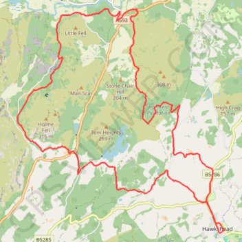
- Distance: 13.0 mi
- Elevation gain: 588 m
- Maximum elevation: 271 m
- Elevation loss: 588 m
- Minimum elevation: 70 m
- Moving time: 1 h 11 m
- Moving speed: 10.9 mph
- Maximum speed: 30.7 mph
- Total time: 1 h 17 m
- Global speed: 10.1 mph
Interactive trail map
Make a donation
Gear up for your next adventure:
As an Amazon Associate, this site earns from qualifying purchases at no extra cost to you.
Trail profile
- Distance: 13.0 mi
- Elevation gain: 588 m
- Maximum elevation: 271 m
- Elevation loss: 588 m
- Minimum elevation: 70 m
- Moving time: 1 h 11 m
- Moving speed: 10.9 mph
- Maximum speed: 30.7 mph
- Total time: 1 h 17 m
- Global speed: 10.1 mph
Make a donation
Gear up for your next adventure:
As an Amazon Associate, this site earns from qualifying purchases at no extra cost to you.
About this trail
Name: E-Mountain Bike Ride: Iron Keld & Hodge Close trail, distance, elevation, map, profile, GPS track
Coordinates: 54.37385 -3.06598 54.41769 -2.99634
Topography: Westmorland and Furness topographic map, elevation, terrain
Make a donation
Gear up for your next adventure:
As an Amazon Associate, this site earns from qualifying purchases at no extra cost to you.
Other hiking, mountain biking, running and outdoor activity trails
Click on a trail to view its statistics, map and profile.
Hiking
United Kingdom > England > Westmorland and Furness > Holme Ground
Distance: 0.9 mi • Elevation gain: 28 m • Maximum elevation: 195 m