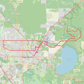
Hatchet Creek Preserve and Waldo Road
Bike
- Distance: 41.9 mi
- Elevation gain: 148 m
- Maximum elevation: 61 m
- Elevation loss: 148 m
- Minimum elevation: 21 m
- Moving time: 3 h 57 m
- Moving speed: 10.6 mph
- Maximum speed: 21.3 mph
- Total time: 4 h 8 m
- Global speed: 10.1 mph
Interactive trail map
Trail profile
- Distance: 41.9 mi
- Elevation gain: 148 m
- Maximum elevation: 61 m
- Elevation loss: 148 m
- Minimum elevation: 21 m
- Moving time: 3 h 57 m
- Moving speed: 10.6 mph
- Maximum speed: 21.3 mph
- Total time: 4 h 8 m
- Global speed: 10.1 mph
About this trail
Name: Hatchet Creek Preserve and Waldo Road trail, distance, elevation, map, profile, GPS track
Coordinates: 29.65400 -82.38894 29.71669 -82.18908
Other hiking, mountain biking, running and outdoor activity trails
Click on a trail to view its statistics, map and profile.
Hawthorne Trail and Longleaf Flatwoods
United States > Florida > Alachua County > Gainesville
Bike
Distance: 35.1 mi • Elevation gain: 235 m • Maximum elevation: 52 m
Newmans Lake State Forest - Sparrow Hiking Trail
United States > Florida > Alachua County > Copeland Settlement
Distance: 1.9 mi • Elevation gain: 17 m • Maximum elevation: 39 m
Morning Side Nature Center Trails
United States > Florida > Alachua County > Ruthland
Distance: 2.8 mi • Elevation gain: 12 m • Maximum elevation: 45 m
Windsor via Hawthorne Road
United States > Florida > Alachua County > Gainesville
Distance: 46.8 mi • Elevation gain: 225 m • Maximum elevation: 61 m
Morning Side Nature Center
United States > Florida > Alachua County > Gainesville
Distance: 2.2 mi • Elevation gain: 9 m • Maximum elevation: 44 m
Phifer flatwoods and SRR
United States > Florida > Alachua County > Gainesville
Distance: 67.6 mi • Elevation gain: 419 m • Maximum elevation: 56 m
Newman's lake trails
United States > Florida > Alachua County > Gainesville
Distance: 62.2 mi • Elevation gain: 312 m • Maximum elevation: 59 m
Newmans Lake State Forest - West Interpretive Trail
United States > Florida > Alachua County > Copeland Settlement
Distance: 0.8 mi • Elevation gain: 5 m • Maximum elevation: 31 m