Avondloop
Total: 10.2km
- Distance: 6.3 mi
- Elevation gain: 32 m
- Maximum elevation: 28 m
- Elevation loss: 34 m
- Minimum elevation: 20 m
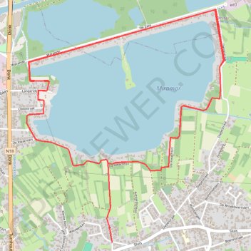
Interactive trail map
Trail profile
- Distance: 6.3 mi
- Elevation gain: 32 m
- Maximum elevation: 28 m
- Elevation loss: 34 m
- Minimum elevation: 20 m
About this trail
Name: Avondloop trail, distance, elevation, map, profile, GPS track
Start: 7, De Mosten, Sluis, Mol, Turnhout, Antwerp, Flanders, 2400, Belgium (51.21023 5.12574)
End: De Kwachten, Sluis, Mol, Turnhout, Antwerp, Flanders, 2400, Belgium (51.21516 5.12217)
Coordinates: 51.21023 5.11697 51.22526 5.13733
Other hiking, mountain biking, running and outdoor activity trails
Click on a trail to view its statistics, map and profile.
Riethoven naar Oostenrijk
Netherlands > North Brabant > Riethoven > Eind
Distance: 573.0 mi • Elevation gain: 13,629 m • Maximum elevation: 1,897 m
Eurovelo 15 - Strasbourg Rotterdam
France > Grand Est > Bas-Rhin > Strasbourg
Distance: 554.1 mi • Elevation gain: 2,104 m • Maximum elevation: 146 m