Traralgon Railway Reservoir Walk
- Distance: 1.9 mi
- Elevation gain: 43 m
- Maximum elevation: 78 m
- Elevation loss: 44 m
- Minimum elevation: 56 m
- Moving time: 38 m 1 s
- Moving speed: 3.0 mph
- Maximum speed: 4.0 mph
- Total time: 38 m 1 s
- Global speed: 3.0 mph
Interactive trail map
Trail profile
- Distance: 1.9 mi
- Elevation gain: 43 m
- Maximum elevation: 78 m
- Elevation loss: 44 m
- Minimum elevation: 56 m
- Moving time: 38 m 1 s
- Moving speed: 3.0 mph
- Maximum speed: 4.0 mph
- Total time: 38 m 1 s
- Global speed: 3.0 mph
About this trail
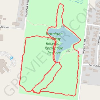
Name: Traralgon Railway Reservoir Walk trail, distance, elevation, map, profile, GPS track
Start: Hickox Street, Traralgon, City of Latrobe, Victoria, 3844, Australia (-38.21132 146.53087)
End: Hickox Street, Traralgon, City of Latrobe, Victoria, 3844, Australia (-38.21113 146.53084)
Coordinates: -38.21381 146.52603 -38.20795 146.53098