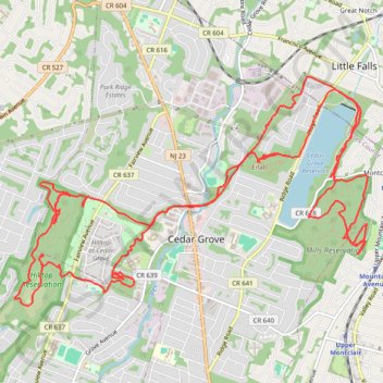
Cedar Grove
Afternoon Ride
- Distance: 14.9 mi
- Elevation gain: 401 m
- Maximum elevation: 210 m
- Elevation loss: 403 m
- Minimum elevation: 85 m
- Moving time: 2 h 52 m
- Moving speed: 5.2 mph
- Maximum speed: 21.8 mph
- Total time: 2 h 58 m
- Global speed: 5.0 mph
Interactive trail map
Trail profile
- Distance: 14.9 mi
- Elevation gain: 401 m
- Maximum elevation: 210 m
- Elevation loss: 403 m
- Minimum elevation: 85 m
- Moving time: 2 h 52 m
- Moving speed: 5.2 mph
- Maximum speed: 21.8 mph
- Total time: 2 h 58 m
- Global speed: 5.0 mph
About this trail
Name: Cedar Grove trail, distance, elevation, map, profile, GPS track
Coordinates: 40.84505 -74.25300 40.86790 -74.20634
Other hiking, mountain biking, running and outdoor activity trails
Click on a trail to view its statistics, map and profile.
Mills Reservation Trails
United States > New Jersey > Essex County > Montclair > Upper Montclair
Distance: 8.5 mi • Elevation gain: 240 m • Maximum elevation: 173 m
Cedar Grove Hilltop Reservation
United States > New Jersey > Essex County > Cedar Grove
Distance: 14.0 mi • Elevation gain: 400 m • Maximum elevation: 211 m
Hilltop Reservation
United States > New Jersey > Essex County > Cedar Grove
Distance: 11.5 mi • Elevation gain: 302 m • Maximum elevation: 201 m
Cedar Grove
United States > New Jersey > Essex County > Newark
Afternoon Ride
Distance: 26.8 mi • Elevation gain: 399 m • Maximum elevation: 163 m