
Eagle Crag Loop
Loop hike from Great Langdale Beck to Eagle Crag via Pike Howe, Harrison Stickle, Thunacar Knott, High Raise, Sergeant's Crag, High White Stones, Harrison Combe, Pike of Stickle, Loft Crag, Thorn Crag, Mark Gate and Dungeon Ghyll in the Lake District National Park. #Hiking #Loop #Nature #Mountain #Park
- Distance: 11.1 mi
- Elevation gain: 1,096 m
- Maximum elevation: 758 m
- Elevation loss: 1,096 m
- Minimum elevation: 96 m
- Moving time: 5 h 19 m
- Moving speed: 2.1 mph
- Maximum speed: 5.3 mph
- Total time: 7 h 57 m
- Global speed: 1.4 mph
Interactive trail map
Trail profile
- Distance: 11.1 mi
- Elevation gain: 1,096 m
- Maximum elevation: 758 m
- Elevation loss: 1,096 m
- Minimum elevation: 96 m
- Moving time: 5 h 19 m
- Moving speed: 2.1 mph
- Maximum speed: 5.3 mph
- Total time: 7 h 57 m
- Global speed: 1.4 mph
About this trail
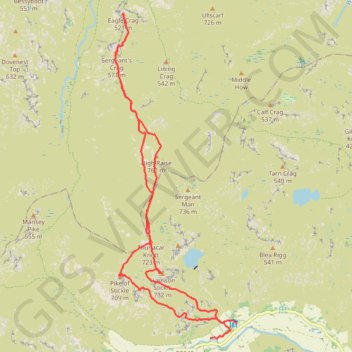
Name: Eagle Crag Loop trail, distance, elevation, map, profile, GPS track
Start: B5343, Lakes, Westmorland and Furness, England, LA22 9JY, United Kingdom (54.44632 -3.09594)
Coordinates: 54.44629 -3.12263 54.49905 -3.08857
Topography: Westmorland and Furness topographic map, elevation, terrain
Other hiking, mountain biking, running and outdoor activity trails
Click on a trail to view its statistics, map and profile.
Bowfell, Shelter Crags, Third Crinkle (Gunson Knott), Crinkle Crags Long Top, South Top and Pike of Blisco Loop
United Kingdom > England > Westmorland and Furness
Distance: 9.6 mi • Elevation gain: 1,136 m • Maximum elevation: 885 m
Pavey Ark via Jack's Rake
United Kingdom > England > Westmorland and Furness
Distance: 5.2 mi • Elevation gain: 757 m • Maximum elevation: 715 m