Thank you for supporting this site ❤️
Make a donation
Make a donation
Gear up for your next adventure:
As an Amazon Associate, this site earns from qualifying purchases at no extra cost to you.
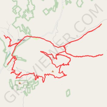
Pitkin Area Trails
- Distance: 41.4 mi
- Elevation gain: 1,886 m
- Maximum elevation: 3,407 m
- Elevation loss: 1,886 m
- Minimum elevation: 2,764 m
- Moving time: 3 h 44 m
- Moving speed: 11.1 mph
- Maximum speed: 32.8 mph
- Total time: 5 h 24 m
- Global speed: 7.7 mph
Interactive trail map
Thank you for supporting this site ❤️
Make a donation
Make a donation
Gear up for your next adventure:
As an Amazon Associate, this site earns from qualifying purchases at no extra cost to you.
Trail profile
- Distance: 41.4 mi
- Elevation gain: 1,886 m
- Maximum elevation: 3,407 m
- Elevation loss: 1,886 m
- Minimum elevation: 2,764 m
- Moving time: 3 h 44 m
- Moving speed: 11.1 mph
- Maximum speed: 32.8 mph
- Total time: 5 h 24 m
- Global speed: 7.7 mph
Thank you for supporting this site ❤️
Make a donation
Make a donation
Gear up for your next adventure:
As an Amazon Associate, this site earns from qualifying purchases at no extra cost to you.
About this trail
Name: Pitkin Area Trails trail, distance, elevation, map, profile, GPS track
Start: 441, Grasshopper Road, Gunnison County, Colorado, 81241, United States (38.61320 -106.53643)
End: 441, Grasshopper Road, Gunnison County, Colorado, 81241, United States (38.61322 -106.53646)
Coordinates: 38.57080 -106.53652 38.62316 -106.42325
Thank you for supporting this site ❤️
Make a donation
Make a donation
Gear up for your next adventure:
As an Amazon Associate, this site earns from qualifying purchases at no extra cost to you.