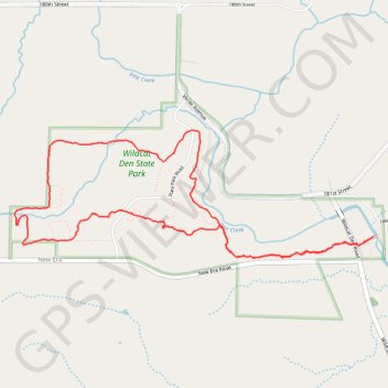
Wildcat Den State Park Loop Trail in Iowa
This loop trail at Wildcat Den State Park offers a delightful hiking experience characterized by scenic views and diverse terrain. As you traverse the trail, you'll encounter striking rock formations like Steamboat Rock and the intriguing Devil’s Punchbowl, which add to the park's unique geological charm. The surrounding wooded areas and elevated paths provide a peaceful escape, making it an ideal destination for both casual hikers and nature enthusiasts. #Hiking #Loop #Rock #Forest #Nature
- Distance: 4.2 mi
- Elevation gain: 150 m
- Maximum elevation: 228 m
- Elevation loss: 150 m
- Minimum elevation: 175 m
- Moving time: 1 h 40 m
- Moving speed: 2.5 mph
- Maximum speed: 3.6 mph
- Total time: 1 h 40 m
- Global speed: 2.5 mph
Interactive trail map
Trail profile
- Distance: 4.2 mi
- Elevation gain: 150 m
- Maximum elevation: 228 m
- Elevation loss: 150 m
- Minimum elevation: 175 m
- Moving time: 1 h 40 m
- Moving speed: 2.5 mph
- Maximum speed: 3.6 mph
- Total time: 1 h 40 m
- Global speed: 2.5 mph
About this trail
Name: Wildcat Den State Park Loop Trail in Iowa trail, distance, elevation, map, profile, GPS track
Start: Wildcat Den Road, Muscatine County, Iowa, United States (41.46687 -90.86870)
End: Wildcat Den Road, Muscatine County, Iowa, United States (41.46702 -90.86879)
Coordinates: 41.46620 -90.89474 41.47345 -90.86757