Ribnicka Skala (Korab)
- Distance: 16.1 mi
- Elevation gain: 1,696 m
- Maximum elevation: 2,268 m
- Elevation loss: 1,694 m
- Minimum elevation: 901 m
- Moving time: 7 h 50 m
- Moving speed: 2.1 mph
- Maximum speed: 6.2 mph
- Total time: 11 h 49 m
- Global speed: 1.4 mph
Interactive trail map
Trail profile
- Distance: 16.1 mi
- Elevation gain: 1,696 m
- Maximum elevation: 2,268 m
- Elevation loss: 1,694 m
- Minimum elevation: 901 m
- Moving time: 7 h 50 m
- Moving speed: 2.1 mph
- Maximum speed: 6.2 mph
- Total time: 11 h 49 m
- Global speed: 1.4 mph
About this trail
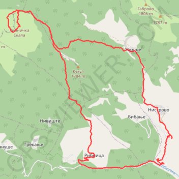
Name: Ribnicka Skala (Korab) trail, distance, elevation, map, profile, GPS track
Start: Ribnica, Municipality of Mavrovo and Rostusha, North Macedonia (41.71687 20.60490)
End: Ribnica, Municipality of Mavrovo and Rostusha, North Macedonia (41.71703 20.60491)
Coordinates: 41.71561 20.57337 41.76521 20.64298