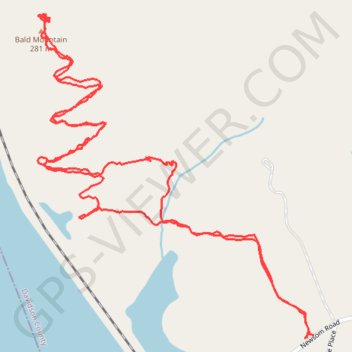
Bald Mountain Trail
- Distance: 2.8 mi
- Elevation gain: 119 m
- Maximum elevation: 286 m
- Elevation loss: 119 m
- Minimum elevation: 180 m
- Moving time: 1 h 33 m
- Moving speed: 1.8 mph
- Maximum speed: 4.5 mph
- Total time: 2 h 58 m
- Global speed: 0.9 mph
Interactive trail map
Trail profile
- Distance: 2.8 mi
- Elevation gain: 119 m
- Maximum elevation: 286 m
- Elevation loss: 119 m
- Minimum elevation: 180 m
- Moving time: 1 h 33 m
- Moving speed: 1.8 mph
- Maximum speed: 4.5 mph
- Total time: 2 h 58 m
- Global speed: 0.9 mph
About this trail
Name: Bald Mountain Trail trail, distance, elevation, map, profile, GPS track
End: Newsom Road, Newsom, Davidson County, North Carolina, United States (35.53918 -80.18865)
Coordinates: 35.53918 -80.19625 35.54665 -80.18845