
Snow Goose Loop Trail in Middle Run Valley Natural Area Park
The Snow Goose Loop Trail offers a scenic route through varied natural landscapes, making it a popular trail among hikers and bird watchers. Winding through woodlands and near gentle creeks, this trail provides visitors with sightings of native flora and fauna, including numerous bird species that inhabit the area. Well-connected to neighboring White Clay Creek State Park, the trail system here combines with others to create extended paths, making it an enjoyable loop for hikers looking for both a peaceful escape and engaging terrain features like rolling hills and stream crossings. #Hiking #Loop #Forest #Nature
- Distance: 2.3 mi
- Elevation gain: 76 m
- Maximum elevation: 80 m
- Elevation loss: 75 m
- Minimum elevation: 37 m
- Moving time: 41 m 6 s
- Moving speed: 3.4 mph
- Maximum speed: 5.4 mph
- Total time: 41 m 51 s
- Global speed: 3.4 mph
Interactive trail map
Trail profile
- Distance: 2.3 mi
- Elevation gain: 76 m
- Maximum elevation: 80 m
- Elevation loss: 75 m
- Minimum elevation: 37 m
- Moving time: 41 m 6 s
- Moving speed: 3.4 mph
- Maximum speed: 5.4 mph
- Total time: 41 m 51 s
- Global speed: 3.4 mph
About this trail
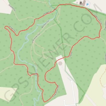
Name: Snow Goose Loop Trail in Middle Run Valley Natural Area Park trail, distance, elevation, map, profile, GPS track
Coordinates: 39.70475 -75.72417 39.71406 -75.71227
Other hiking, mountain biking, running and outdoor activity trails
Click on a trail to view its statistics, map and profile.
Lenape Trail and Snow Goose Trail Loop in Middle Run Valley Natural Area Park
United States > Delaware > New Castle County
The Lenape Trail and Snow Goose Trail Loop offers a delightful hiking experience through diverse landscapes of forests, wetlands, and rolling hills. Hikers can expect to encounter serene stream crossings, scenic views of the natural surroundings, and the chance to spot local wildlife, including various bird…
Distance: 4.7 mi • Elevation gain: 125 m • Maximum elevation: 85 m