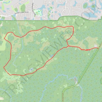
Flatwoods Park Loop Trail
- Distance: 9.0 mi
- Elevation gain: 12 m
- Maximum elevation: 17 m
- Elevation loss: 12 m
- Minimum elevation: 11 m
- Moving time: 1 h 3 m
- Moving speed: 8.5 mph
- Maximum speed: 30.7 mph
- Total time: 2 h 1 s
- Global speed: 4.5 mph
Interactive trail map
Trail profile
- Distance: 9.0 mi
- Elevation gain: 12 m
- Maximum elevation: 17 m
- Elevation loss: 12 m
- Minimum elevation: 11 m
- Moving time: 1 h 3 m
- Moving speed: 8.5 mph
- Maximum speed: 30.7 mph
- Total time: 2 h 1 s
- Global speed: 4.5 mph
About this trail
Name: Flatwoods Park Loop Trail trail, distance, elevation, map, profile, GPS track
Start: Flatwoods Station Lane, Hillsborough County, Florida, 33647, United States (28.11359 -82.30512)
Coordinates: 28.10174 -82.35042 28.12477 -82.30070