Thank you for supporting this site ❤️
Make a donation
Make a donation
Gear up for your next adventure:
As an Amazon Associate, this site earns from qualifying purchases at no extra cost to you.
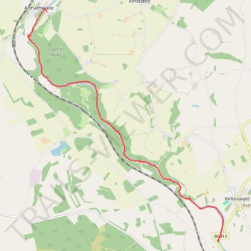
Kayak on River Eden
- Distance: 6.5 mi
- Elevation gain: 109 m
- Maximum elevation: 78 m
- Elevation loss: 130 m
- Minimum elevation: 46 m
- Moving time: 2 h 20 m
- Moving speed: 2.8 mph
- Maximum speed: 6.7 mph
- Total time: 4 h 13 m
- Global speed: 1.5 mph
Interactive trail map
Thank you for supporting this site ❤️
Make a donation
Make a donation
Gear up for your next adventure:
As an Amazon Associate, this site earns from qualifying purchases at no extra cost to you.
Trail profile
- Distance: 6.5 mi
- Elevation gain: 109 m
- Maximum elevation: 78 m
- Elevation loss: 130 m
- Minimum elevation: 46 m
- Moving time: 2 h 20 m
- Moving speed: 2.8 mph
- Maximum speed: 6.7 mph
- Total time: 4 h 13 m
- Global speed: 1.5 mph
Thank you for supporting this site ❤️
Make a donation
Make a donation
Gear up for your next adventure:
As an Amazon Associate, this site earns from qualifying purchases at no extra cost to you.
About this trail
Name: Kayak on River Eden trail, distance, elevation, map, profile, GPS track
Start: B6413, Lazonby, Westmorland and Furness, England, CA10 1BJ, United Kingdom (54.75536 -2.70089)
Coordinates: 54.75517 -2.77414 54.80701 -2.69867
Topography: Westmorland and Furness topographic map, elevation, terrain
Thank you for supporting this site ❤️
Make a donation
Make a donation
Gear up for your next adventure:
As an Amazon Associate, this site earns from qualifying purchases at no extra cost to you.