Hike at Tandy Hills Natural Area
- Distance: 5.2 mi
- Elevation gain: 156 m
- Maximum elevation: 197 m
- Elevation loss: 156 m
- Minimum elevation: 160 m
- Moving time: 1 h 25 m
- Moving speed: 3.6 mph
- Maximum speed: 9.1 mph
- Total time: 1 h 27 m
- Global speed: 3.6 mph
Interactive trail map
Trail profile
- Distance: 5.2 mi
- Elevation gain: 156 m
- Maximum elevation: 197 m
- Elevation loss: 156 m
- Minimum elevation: 160 m
- Moving time: 1 h 25 m
- Moving speed: 3.6 mph
- Maximum speed: 9.1 mph
- Total time: 1 h 27 m
- Global speed: 3.6 mph
About this trail
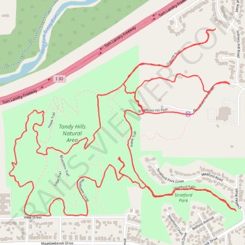
Name: Hike at Tandy Hills Natural Area trail, distance, elevation, map, profile, GPS track
Start: Broadcast Hill Street, Fort Worth, Tarrant County, Texas, 76103, United States (32.75154 -97.26486)
End: Broadcast Hill Street, Fort Worth, Tarrant County, Texas, 76103, United States (32.75155 -97.26488)
Coordinates: 32.74524 -97.27740 32.75418 -97.26451
Other hiking, mountain biking, running and outdoor activity trails
Click on a trail to view its statistics, map and profile.
Hike at Tandy Hills Natural Area
United States > Texas > Tarrant County > Fort Worth
Distance: 3.3 mi • Elevation gain: 95 m • Maximum elevation: 196 m
Tandy Hills Trails
United States > Texas > Tarrant County > Fort Worth
Distance: 8.0 mi • Elevation gain: 229 m • Maximum elevation: 195 m