Kanjon Sušice
- Distance: 10.7 mi
- Elevation gain: 506 m
- Maximum elevation: 1,093 m
- Elevation loss: 507 m
- Minimum elevation: 734 m
- Moving time: 4 h 46 m
- Moving speed: 2.3 mph
- Maximum speed: 4.9 mph
- Total time: 7 h 3 m
- Global speed: 1.5 mph
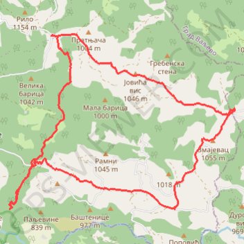
Interactive trail map
Trail profile
- Distance: 10.7 mi
- Elevation gain: 506 m
- Maximum elevation: 1,093 m
- Elevation loss: 507 m
- Minimum elevation: 734 m
- Moving time: 4 h 46 m
- Moving speed: 2.3 mph
- Maximum speed: 4.9 mph
- Total time: 7 h 3 m
- Global speed: 1.5 mph
About this trail
Name: Kanjon Sušice trail, distance, elevation, map, profile, GPS track
Coordinates: 44.14286 19.58246 44.17419 19.63856
Other hiking, mountain biking, running and outdoor activity trails
Click on a trail to view its statistics, map and profile.
Vodopadi Susice i Dubrasnice 01.11.2020.
Serbia > Central Serbia > Macva Administrative District > Ljubovija Municipality > Gornje Koslje > Доње Кошље
Distance: 6.4 mi • Elevation gain: 536 m • Maximum elevation: 915 m
2022_Yu
Slovenia > Ajdovščina > Žapuže
Distance: 1,526.9 mi • Elevation gain: 32,048 m • Maximum elevation: 1,950 m
Gornje Koslje - Tresnjica Gorge - Dubrasnica Waterfall - Pos...
Serbia > Central Serbia > Macva Administrative District > Ljubovija Municipality > Gornje Koslje
Distance: 7.6 mi • Elevation gain: 631 m • Maximum elevation: 917 m
Jablanik i Medvednik
Serbia > Central Serbia > Kolubara Administrative District > Vujinovaca
Distance: 17.3 mi • Elevation gain: 1,524 m • Maximum elevation: 1,269 m