Thank you for supporting this site ❤️
Make a donation
Make a donation
Gear up for your next adventure:
As an Amazon Associate, this site earns from qualifying purchases at no extra cost to you.
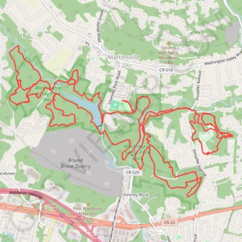
Chimney Rock
- Distance: 20.9 mi
- Elevation gain: 630 m
- Maximum elevation: 127 m
- Elevation loss: 630 m
- Minimum elevation: 47 m
- Moving time: 3 h 18 m
- Moving speed: 6.3 mph
- Maximum speed: 22.3 mph
- Total time: 3 h 40 m
- Global speed: 5.7 mph
Interactive trail map
Thank you for supporting this site ❤️
Make a donation
Make a donation
Gear up for your next adventure:
As an Amazon Associate, this site earns from qualifying purchases at no extra cost to you.
Trail profile
- Distance: 20.9 mi
- Elevation gain: 630 m
- Maximum elevation: 127 m
- Elevation loss: 630 m
- Minimum elevation: 47 m
- Moving time: 3 h 18 m
- Moving speed: 6.3 mph
- Maximum speed: 22.3 mph
- Total time: 3 h 40 m
- Global speed: 5.7 mph
Thank you for supporting this site ❤️
Make a donation
Make a donation
Gear up for your next adventure:
As an Amazon Associate, this site earns from qualifying purchases at no extra cost to you.
About this trail
Name: Chimney Rock trail, distance, elevation, map, profile, GPS track
Coordinates: 40.57945 -74.58250 40.60307 -74.53659
Thank you for supporting this site ❤️
Make a donation
Make a donation
Gear up for your next adventure:
As an Amazon Associate, this site earns from qualifying purchases at no extra cost to you.