Make a donation
Gear up for your next adventure:
As an Amazon Associate, this site earns from qualifying purchases at no extra cost to you.
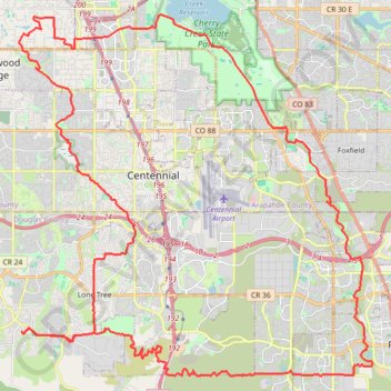
Douglas County Gravel/Unpaved Cycling
Gravel cycling route
- Distance: 45.6 mi
- Elevation gain: 728 m
- Maximum elevation: 1,923 m
- Elevation loss: 726 m
- Minimum elevation: 1,674 m
- Moving time: 3 h 20 m
- Moving speed: 13.7 mph
- Maximum speed: 31.2 mph
- Total time: 3 h 35 m
- Global speed: 12.7 mph
Interactive trail map
Make a donation
Gear up for your next adventure:
As an Amazon Associate, this site earns from qualifying purchases at no extra cost to you.
Trail profile
- Distance: 45.6 mi
- Elevation gain: 728 m
- Maximum elevation: 1,923 m
- Elevation loss: 726 m
- Minimum elevation: 1,674 m
- Moving time: 3 h 20 m
- Moving speed: 13.7 mph
- Maximum speed: 31.2 mph
- Total time: 3 h 35 m
- Global speed: 12.7 mph
Make a donation
Gear up for your next adventure:
As an Amazon Associate, this site earns from qualifying purchases at no extra cost to you.
About this trail
Name: Douglas County Gravel/Unpaved Cycling trail, distance, elevation, map, profile, GPS track
Coordinates: 39.50710 -104.93918 39.63645 -104.77535
Make a donation
Gear up for your next adventure:
As an Amazon Associate, this site earns from qualifying purchases at no extra cost to you.
Other hiking, mountain biking, running and outdoor activity trails
Click on a trail to view its statistics, map and profile.
Douglas County Gravel/Unpaved Cycling
United States > Colorado > Douglas County
Distance: 27.7 mi • Elevation gain: 701 m • Maximum elevation: 1,938 m
Littleton Gravel/Unpaved Cycling
United States > Colorado > Arapahoe County > Littleton
Distance: 35.5 mi • Elevation gain: 313 m • Maximum elevation: 1,710 m
Rueter Hess Reservoir
United States > Colorado > Douglas County > Lone Tree
mtb mountainbiking biking trails
Distance: 24.9 mi • Elevation gain: 718 m • Maximum elevation: 2,011 m