Cedar Bluff Nature Loop Trail in Beavers Bend State Park
The Cedar Bluff Nature Loop Trail in Beavers Bend State Park provides a delightful hiking experience, showcasing the lush landscapes and diverse wildlife of the area. As you traverse the well-marked path, you'll encounter towering trees, vibrant flora, and the soothing sounds of nearby streams, all contributing to a serene natural ambiance. The trail's moderate elevation offers rewarding viewpoints, especially during the fall when the foliage bursts into rich autumn colors, making it a perfect outing for both seasoned hikers and families alike. #Hiking #Loop #Forest #Nature
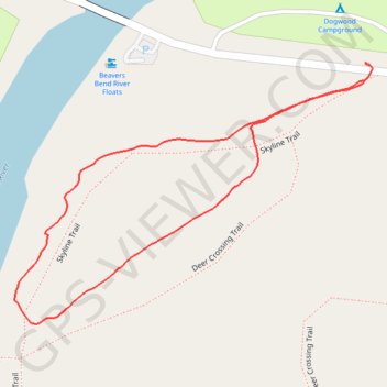
- Distance: 0.9 mi
- Elevation gain: 41 m
- Maximum elevation: 165 m
- Elevation loss: 42 m
- Minimum elevation: 139 m
- Moving time: 29 m 6 s
- Moving speed: 1.8 mph
- Maximum speed: 3.8 mph
- Total time: 38 m 35 s
- Global speed: 1.3 mph
Interactive trail map
Trail profile
- Distance: 0.9 mi
- Elevation gain: 41 m
- Maximum elevation: 165 m
- Elevation loss: 42 m
- Minimum elevation: 139 m
- Moving time: 29 m 6 s
- Moving speed: 1.8 mph
- Maximum speed: 3.8 mph
- Total time: 38 m 35 s
- Global speed: 1.3 mph
About this trail
Name: Cedar Bluff Nature Loop Trail in Beavers Bend State Park trail, distance, elevation, map, profile, GPS track
Start: Skyline Trail, McCurtain County, Oklahoma, United States (34.13733 -94.69298)
End: McCurtain County, Oklahoma, United States (34.13756 -94.69296)
Coordinates: 34.13425 -94.69832 34.13756 -94.69285
Other hiking, mountain biking, running and outdoor activity trails
Click on a trail to view its statistics, map and profile.
Skyline Trail Loop in Beavers Bend State Park
United States > Oklahoma > McCurtain County
The Skyline Trail is a challenging loop hike that rewards adventurous visitors with sweeping views of the surrounding Ouachita Mountains, lush forests, glimpses of the Mountain Fork River below and even a hidden waterfall nestled in the forest. The trail leads hikers through rocky paths, forested ridges, and…
Distance: 8.5 mi • Elevation gain: 450 m • Maximum elevation: 263 m