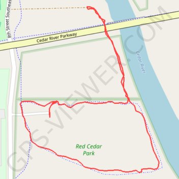
Red Cedar Park Loop
- Distance: 0.9 mi
- Elevation gain: 6 m
- Maximum elevation: 282 m
- Elevation loss: 6 m
- Minimum elevation: 276 m
- Moving time: 25 m 4 s
- Moving speed: 2.1 mph
- Maximum speed: 4.8 mph
- Total time: 29 m 8 s
- Global speed: 1.8 mph
Interactive trail map
Trail profile
- Distance: 0.9 mi
- Elevation gain: 6 m
- Maximum elevation: 282 m
- Elevation loss: 6 m
- Minimum elevation: 276 m
- Moving time: 25 m 4 s
- Moving speed: 2.1 mph
- Maximum speed: 4.8 mph
- Total time: 29 m 8 s
- Global speed: 1.8 mph
About this trail
Name: Red Cedar Park Loop trail, distance, elevation, map, profile, GPS track
Start: 948, 8th Street Southeast, Waverly, Bremer County, Iowa, 50677, United States (42.71277 -92.45993)
End: 949, 8th Street Southeast, Waverly, Bremer County, Iowa, 50677, United States (42.71268 -92.45993)
Coordinates: 42.71145 -92.46076 42.71485 -92.45688